As the world continues to grow and change, our understanding of it must evolve as well. At Graphic Education, we pride ourselves on providing the highest quality maps based on the most up-to-date information and credible sources. To assist you in selecting the perfect map for your needs, we've prepared this blog post to explore the differences between political maps and physical maps, as well as the advantages of each. So, grab your compass and let's begin!
Political Maps: A Journey through Borders and Boundaries

Political maps provide an overview of the world's political landscape by displaying international and administrative boundaries, cities, and other human-made features. They help us understand the relationships between nations and regions, as well as the distribution of political power around the globe.
Advantages of Political Maps
International Relations and Diplomacy
Political maps are essential for understanding the relationships between countries and their geopolitical significance. By showing territorial boundaries and capital cities, they enable diplomats, policymakers, and scholars to analyse international relations, identify areas of conflict or cooperation, and develop informed strategies.
Travel Planning and Navigation
Political maps are a great resource for travellers and adventurers who want to plan their trips and navigate foreign lands. By showing the locations of cities, towns, and major transportation routes, these maps make it easy to determine the best paths to take and the most interesting places to visit.
Educational Tool
Teachers and students can use political maps to learn about different countries, their capitals, and the historical context that shaped their borders. These maps are a valuable resource for expanding one's knowledge of the world and its diverse cultures, politics, and histories.
Physical Maps: Exploring the Earth's Natural Wonders

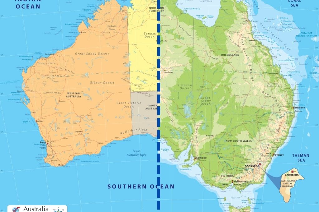
Physical maps showcase the Earth's natural features, such as mountains, rivers, deserts, and forests. These maps emphasise the geographic and topographic characteristics of the Earth's surface, providing insights into the underlying geological structures and processes that have shaped our planet.
Advantages of Physical Maps
Geographical and Environmental Understanding
Physical maps allow us to gain a deeper understanding of the Earth's diverse landscapes and environments. By illustrating the locations of various landforms, such as mountain ranges, river systems, and deserts, these maps help us appreciate the beauty and complexity of our planet's geography. Additionally, physical maps can be used to study climate patterns, natural resources, and ecological systems.
Adventure and Exploration
For outdoor enthusiasts, physical maps are indispensable tools for planning and navigating expeditions. They provide essential information on elevation, terrain, and natural features, enabling adventurers to select the best routes, avoid potential hazards, and discover hidden gems. From hiking and mountain climbing to rafting and off-roading, physical maps help ensure a safe and enjoyable experience in the great outdoors.
Scientific Research and Education
Physical maps are valuable resources for scientists, researchers, and educators who study the Earth's natural processes and ecosystems. They provide a wealth of information on geological formations, climate zones, and biomes, which can be used to conduct research and develop hypotheses about the Earth's past, present, and future. These maps also serve as effective teaching tools, helping students visualise and comprehend complex concepts related to geology, ecology, and meteorology.
Choosing the Right Map for Your Needs
Now that we've explored the differences between political and physical maps, as well as the advantages of each, you may be wondering which type of map is best suited for your needs. The key is to consider your intended purpose and what information is most relevant to your interests.
Decision-Making Factors
Purpose and Interests
If your primary interest lies in understanding international relations, geopolitics, or human-made features such as cities and transportation networks, a political map will likely be the most suitable option. On the other hand, if you're drawn to the natural world and want to explore the Earth's diverse landscapes, a physical map will provide the information you need.
Aesthetics and Design
Consider the visual appeal and design of the map, particularly if you plan to display it as a decorative piece or use it in an educational setting. Political maps typically have a more minimalist design, focusing on clear lines and contrasting colours to highlight boundaries and features. Physical maps, however, often showcase a more intricate and detailed design, with various shades and textures representing different landforms and elevations.
Scale and Detail
The scale and level of detail in a map will also play a role in your decision. Political maps often prioritise the representation of borders and administrative divisions, while physical maps emphasise topographical features. Depending on your specific needs, you may prefer a map that offers a broader overview or one that delves into more intricate details of a particular region.
In a world that is constantly changing, having an accurate and up-to-date map is essential for navigating and understanding the complexities of our planet. Whether you choose a political map to explore the human-made features and relationships between nations, or a physical map to uncover the Earth's natural wonders, Graphic Education has the perfect map to suit your needs.
By examining the advantages and unique features of both political and physical maps, you can make an informed decision that aligns with your interests and goals. So go ahead, immerse yourself in the world of cartography, and embark on a journey of discovery with Graphic Education's high-quality maps. Happy exploring!